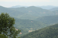
Yesterday (Thursday) I experienced another portion of the Blue Ridge Parkway. From Mt. Pisgah (MM 408) to the exit near Little Switzerland (MM 334) the road was again in good condition and traffic was low with the exception of the area around Asheville. Asheville is a good sized town with Interstates 40 and 26 crossing through town. On the 10 miles around Asheville one had the impression, that many drivers just wanted to "make" part of the Blue Ridge Parkway. Traffic increased tremendously around the town. There were less outlooks on this portion, but since the views kind of repeat a lot, I did not stop as many times as before. The most annoying thing was the many low hanging limbs banging on the various covers on the roof. So far I could not discover any major damage though.

The exit before Spruce Pine, where I planned to spend the night at Walmart, was Little Switzerland. I was interested to visiting that little town. The lady at the visitors center at Craggy Gardens said, that there was no problem and the road was good and continuing to Spruce Pine. So, off I went to Little Switzerland. Off the Parkway, there were only two roads, one was 226A heading to Marion, so I took the other one. After a few miles just behind a nice little church there was the sign "Dead end". I stopped and a couple of locals drove by and explained, that there was no such a road and I had to return to the Parkway. The only problem was, I had to turn around and that is not possible with the Jeep hooked up. So, I had to unhook, turn around and hook up again. Back on the parkway I directly went to Walmart in Spruce Pine. I still don't know what's there about Little Switzerland.
During the evening and all night a major thunderstorm was active in the area and the other morning there was a lot of fog on the hills. I therefore decided to use the major roads heading north. The first part of the road was 14% incline and there were a zillion warning signs and a 15mph speed limit for trucks. I usually honor all signs for trucks since they are there for a reason and my 40'000 lb combination is as heavy as a truck. After refueling in Marion, it was a 135 mile trip on I-40 and I-77 to Fancy Gap, where I-77 crosses the Parkway again and leaves the option open to continue there after the weekend.

In Fancy Gap there is an expensive KOA Kampground and the much cheaper Utt's campground, where I settled for a couple of nights. While it was dry most of the day, it was raining while I was setting up and during the entire evening. The campground is on a steep slope, but the sites are moreless level but on grass with very small gravel areas. They are definitely made for smaller rigs than mine. When leveling up, my rear left jack slipped off the wooden block and could not be moved up nor down. I had to use all the tricks in my toolbox to get the jack loose again, including filling the airbags and slowly moving Genty a few inches. Finally the jack retraced and I could start the leveling process again, this time with a solid gravel base under the wood block.
There are few photos
here.
Location:
| 36.67576N | 80.69017W | 3007 ft |

 From Fancy Gap I took the Interstates for a 150 miles to speed up the process. Driving on the Blue Ridge Parkway is nice, but kind of remains the same and the lookouts are similar from one to another too. The weather was not so nice, so why not take the easy route. En route I got involved in a major traffic jam, where we stood pat for about 90 minutes. 21 state police cars and three ambulances went by and then it turned out that the accident was not even on the interstate but on the exit road.


